
/dv028502-58b9c9783df78c353c3723a0.jpg)
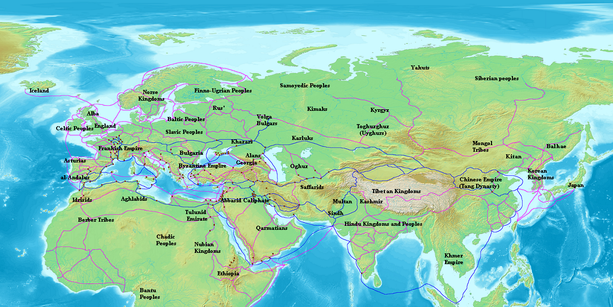
Geography (Applications and History of Geography)
Geography ultimately deals with studying our world. From focusing on landscapes to human demographics, the essence of geography is beautiful. Also, it ought to be taken seriously. The climate change challenge going on in the world proves to everyone that we must take geography as an important form of study. Record temperatures are found worldwide. Many species of animals globally have found up dead or dying. Hurricanes are increasing in their intensity or magnitude that has caused damage in places like the Bahamas and parts of America. When cities flood and the Amazon rainforest is burning up, then you know that our fight for environmental justice is more than a matter of solutions. It is a quest to save human life and animal life in general. That is why on Earth Day each year in April, human beings stand up in favor of caring for Nature for real. We have only one Earth, and we are entitled to improve upon it in the best way possible. There are many applications and occupations as it relates to geography. The branches of geography are numerous like physical geography, human geography, geomatics, regional geography, and other related fields. I took many geography classes before in college years ago, and those classes certainly gave me more crucial insights on the world society. Today, we live in a much different world than even 10 years ago. We should maintain our core principles while advancing compassion to fellow human beings.
One of the best applications of using geography is about the geographic information system (or GIS). The GIS is an advanced system that is created to capture, store, manipulate, manage, and present spatial or geographic data. GIS can help to analyze maps, to create interactive queries (user created searches), and using information about other applications. Today, advanced technologies and other methods relate to GIS. Longitude, latitude, elevation, x, y, and z coordinates are represented in that technology. Its history goes back long decades. Geographic information system was first known to be used by Roger Tomlinson by the year of 1968. He mentioned in in his paper called, “A Geographic Information System for Regional Planning.” The French geographer Charles Picquet represented the 48 districts of the city of Paris by halftone color gradient according to the number of deaths by cholera per 1,000 inhabitants. In 1854 John Snow determined the source of a cholera outbreak in London by marking points on a map depicting where the cholera victims lived, and connecting the cluster that he found with a nearby water source. This was one of the earliest successful uses of a geographic methodology in epidemiology. While the basic elements of topography and theme existed previously in cartography, the John Snow map was unique, using cartographic methods not only to depict but also to analyze clusters of geographically dependent phenomena.
By the 20th century, more computer technology was formed to evaluate geographic information. Ottawa, Ontario, Canada was the place where the first operational GIS was instituted by 1960. It was created by the federal Department of Forestry and Rural Development. Developed by Dr. Roger Tomlinson, and it was called the Canada Geographic Information System (CGIS). Its purpose was used to store, analyze, and manipulate data collected for the Canada Land Inventory – an effort to determine the land capability for rural Canada by mapping information about soils, agriculture, recreation, wildlife, waterfowl, forestry and land use at a scale of 1:50,000. A rating classification factor was also added to permit analysis. Modern GIS technologies have digital information. With the wide availability of ortho-rectified imagery (from satellites, aircraft, Helikites and UAVs), heads-up digitizing is becoming the main avenue through which geographic data is extracted. Heads-up digitizing involves the tracing of geographic data directly on top of the aerial imagery instead of by the traditional method of tracing the geographic form on a separate digitizing tablet (heads-down digitizing). The GeaBios system uses geographical information as well. In local, state, and federal governments, they use programs that deal with public safety, parks and recreation, public works, economic development, and other aspects of society with the usage of geographic research.


Tons of occupations work with geography all of the time. These careers deal with researching weather and analyzing facts. There are cartographers who develop maps, charts, diagrams, travel guides, and spreadsheets. They can work for the government. Some survey lands. The field of cartography have existed for centuries and thousands of years. Others advance conservation. Some people are environmental consultants. They study the air, the water, and other ecosystems in finding ways to improve the environment. Some workers in geography are town planners. They work in management and development involved in the creation of villages, towns, cities, and other rural areas. Many of them have an extreme amount of qualifications. They not only create plans. They balance budgets, deal with zoning laws, and use tools to advance the tools that outline the necessity to enhance the environment. A geographic information system officer use the GIS computer system to analyze complex geographical information .The data can be applies such as meteorology, oil, gas, telecommunication, and environmental issues. There are recycle officers and landscape architects. Many places like stores and parks require architects to make sure that they are fundamentally sound and have powerful infrastructures. Many people are teachers of geography. They teach skills and knowledge to the youth in a secondary school, a college, and other educational services. These teachers are mostly in middle and high school among secondary educations. Other geography teachers work in colleges including universities across the world. Therefore, careers are very diverse as it relates to geography.
There is new research and discoveries about geography all of the time. Recently in 2019, people found more meltwater lakes on the surface of the East Antarctic ice sheet. This is a study led by the Durham University, UK. They found more than 65,000 lakes found. There is a GIS and eDNA analysis system that has successfully used to discover new habitats of a rare salamander. Researchers identified an unknown population of the endangered Yamato salamander.
:max_bytes(150000):strip_icc()/eratosthenes_photo-5c8d7bcc46e0fb00016ee0b8.jpg)
Geographic history is always part of human history. The history of geography is always long and complex. It differs from time, place, and culture. Today, people know about cartography from Muslims, Chinese people, Europeans, Africans, and other human beings throughout the world. Geography comes from the Greek word γεωγραφία or geographia. The word means “to describe or write about the Earth.” The scholar Eratosthenes (275-194 B.C.) was the first person to have used the word geography. During the time of ancient Egypt, the ancient Egyptians viewed the Nile River as the center of their power. There were many oases to the east and the west of the Nile. The ancient Egyptians viewed these regions as locations of various gods like Amon. The Kushitic region was to the south of Egypt. It was known as far as the 4th cataract. The ancient Egyptians and the ancient Kushites traded with each other, and in many cases intermarried with each other. Punt was a region south along the shores of the Red Sea. Various Asiatic peoples were known as Retenu, Kanaan, Que, Harranu, or Khatti (Hittites). At various times especially in the Late Bronze Age Egyptians had diplomatic and trade relationships with Babylonia and Elam. The Mediterranean was called "the Great Green" and was believed to be part of a world encircling ocean. Europe was unknown to many ancient Egyptians thousands of years ago, although it may have become part of the Egyptian world view in Phoenician times. To the west of Asia lay the realms of Keftiu, possibly Crete, and Mycenae (thought to be part of a chain of islands that joined Cyprus, Crete, Sicily and later perhaps Sardinia, Corsica and the Balarics to Africa).
The oldest known world maps came from ancient Babylon form the 9th century B.C. The best known Babylonian world map was the Imago Mundi of 600 B.C. This map was reconstructed by Eckhard Unger. It showed Babylon on the Euphrates River being surrounded by a circular landmass showing Assyria, Uratu, and other cities. It was surrounded by a “bitter fiver” or Oceanus with seven island arranged around it to form a seven pointed star. The accompanying text showed the seven outer regions beyond the encircling oceans. The descriptions of the five of them survived. In contrast to the Imago Mundi, an earlier Babylonian world map dating back to the 9th century BC depicted Babylon as being further north from the center of the world, though it is not certain what that center was supposed to represent. The Greco-Roman world has many geographers.
Geography discovery continued for thousands of years. The ancient Greeks saw the poet Homer as the founder of geography, but geography existed long before Homer. Homer wrote the Iliad and the Odyssey. These forms of literature or pieces of prose deal with a large amount of geographical information. Homer believed that the world was circular ringed by a single massive ocean. The works shows that the Greeks by the 8th century B.C. knew a great deal about their surroundings (including the eastern Mediterranean). The poems contain a large number of place names and descriptions. Many of these names are uncertain about their real location. Thales of Miletus was one of the first known philosophers to have wondered about the shape of the world. He said that the world was based on water, and that all things grew out of it. He also mentioned that many of the astronomical and mathematical rules that would allow geography to be studied scientifically. His successor was Anaximander. Anaximander was the first person to have attempted to create a scale map of the known world to the Greeks and to have introduced the gnomon to Ancient Greece. Hecataeus of Miletus created a different form of geography. He advocated the mathematical calculations of Thales and Anaximander. He learned about the world by getting previous works and speaking to the sailors who came through the busy port of Miletus. From these accounts, Hecataeus created a detailed prose account about his region. Herodotus’ Histories is a work of history. It showed geographic descriptions of Egypt, Scythia, Persia, and Asia Minor. It also mentioned India. There is a description of Africa. He said that the land was surrounded by a sea.
Regardless, Herodotus made important observations about geography. He is the first to have noted the process by which large rivers, such as the Nile, build up deltas, and is also the first recorded as observing that winds tend to blow from colder regions to warmer ones.
Pythagoras was perhaps the first to propose a spherical world, arguing that the sphere was the most perfect form. This idea was embraced by Plato and Aristotle presented empirical evidence to verify this. He noted that the Earth's shadow during an eclipse is curved, and also that stars increase in height as one moves north. Eudoxus of Cnidus used the idea of a sphere to explain how the sun created differing climatic zones based on latitude. This led the Greeks to believe in a division of the world into five regions. At each of the poles was an uncharitably cold region. While extrapolating from the heat of the Sahara it was deduced that the area around the equator was unbearably hot. Between these extreme regions both the northern and southern hemispheres had a temperate belt suitable for human habitation. The Hellenistic period saw more geographical researchers. Hanno the Navigator came into Sierra Leone in Africa. Other Phoenicians possibly circumnavigated Africa. This was during the 4th century B.C. when the Greek explorer Pytheas traveled into northeast Europe and circles the British Isles. He found many more people in those lands than expected. There were Julius Caesar’s invasions of Britain and Germany. Augustus had expeditions to Arabia Felix and Ethiopia (or Nubia). Alexander the Great traveled as far as Iran and India with his army. Many geographers and writers were with him to observe what they saw.
The ancient Greeks divided the world into three continents, Europe, Asia, and Libya (Africa). The Hellespont formed the border between Europe and Asia. The border between Asia and Libya was generally considered to be the Nile River, but some geographers, such as Herodotus objected to this. Herodotus argued that there was no difference between the people on the east and west sides of the Nile, and that the Red Sea was a better border. The relatively narrow habitable band was considered to run from the Atlantic Ocean in the west to an unknown sea somewhere east of India in the east. The southern portion of Africa was unknown (to the ancient Greeks), as was the northern portion of Europe and Asia, so it was believed that they were circled by a sea. The ancient Greeks tried to find the size of the Earth. Eratosthenes tried to calculate the Earth’s circumference by measuring the angle of the sun at two different locations. His numbers were problematic, but most of the errors cancelled themselves out. He got an accurate figure. Since the distance from the Atlantic to India was roughly known, this raised the important question of what was in the vast region east of Asia and to the west of Europe. Crates of Mallus proposed that there were in fact four inhabitable land masses, two in each hemisphere. In Rome a large globe was created depicting this world. That some of the figures Eratosthenes had used in his calculation were considerably in error became known, and Posidonius set out to get a more accurate measurement. This number actually was considerably smaller than the real one, but it became accepted that the eastern part of Asia was not a huge distance from Europe. Many Roman geographers did their own research. Strabo had works on geography. Ptolemy did his own research. By the time of 90-168 A.D, the Silk Road was in existence. Ptolemy’s Geographia helped to open up the human understanding of the nature of geography. The ancient Romans used maps, transportation, and triangulation to develop research in geography. They had land surveyors, cartographical research, engineering surveyors, and military surveyors. Around AD 400 a scroll map called the Peutinger Table was made of the known world to the ancient Romans, featuring the Roman road network. Besides the Roman Empire which at that time spanned from Britain to the Middle East and Africa, the map includes India, Sri Lanka and China. Cities are demarcated using hundreds of symbols. It measures 1.12 ft. high and 22.15 ft. long. The tools and principles of geography used by the Romans would be closely followed with little practical improvement for the next 700 years.
Ancient Indian geographers had their own theories on the origin of the Earth. Some of them believed that the Earth was formed by the solidification of gaseous matter and the earth’s crust is made of hard rocks (sila), clay (bhuih), and sand (asma). Theories were also propounded to explain earthquakes (bhukamp) and it was assumed that earth, air and water combined to cause earthquakes. The Arthashastra, a compendium by Kautilya (also known as Chanakya) contains a range of geographical and statistical information about the various regions of India. The composers of the Puranas divided the known world into seven continents of dwipas, Jambu Dwipa, Krauncha Dwipa, Kusha Dwipa, Plaksha Dwipa, Pushkara Dwipa, Shaka Dwipa and Shalmali Dwipa. Descriptions were provided for the climate and geography of each of the dwipas. The Vishnudharmottara Purana (compiled between 300–350 AD) contains six chapters on physical and human geography. It describes peoples, places, and seasons. Varahamihira's Brihat-Samhita gave a thorough treatment of planetary movements, rainfall, clouds and the formation of water. The mathematician-astronomer Aryabhata gave a precise estimate of the earth's circumference in his treatise Āryabhaṭīya. Aryabhata accurately calculated the Earth's circumference as 24,835 miles, which was only 0.2% smaller than the actual value of 24,902 miles. The Mughal chronicles Tuzuk-i-Jehangiri, Ain-i-Akbari and Dastur-ul-aml contain detailed geographical narratives. These were based on the earlier geographical works of India and the advances made by medieval Muslim geographers, particularly the work of Alberuni.
Ancient Chinese geographers were abundant back then. They existed in the 5th century B.C. during the start of the Warring States period (481 B.C. – 221 B.C.). There was the work called the Yu Gong ('Tribute of Yu') chapter of the Shu Jing or Book of Documents, which describes the traditional nine provinces of ancient China, their kinds of soil, their characteristic products and economic goods, their tributary goods, their trades and vocations, their state revenues and agricultural systems, and the various rivers and lakes listed and placed accordingly. The nine provinces at the time of this geographical work were relativity small in size compared to those of modern China.
The book described areas of the Yellow River (including the lower valleys of the Yangtze and the plain between them as well as the Shandong peninsula. It shows area of the west and the most northern parts of the Wei and Han Rivers along the southern parts of modern day Shanxi province). The state of Zin by the 4th century B.C. had many maps. The writings of cartographer Pei Xiu (224-271) referred to geometric grid and mathematically graduated scale to a map. Chinese historical texts have a geographical section. The ancient Chinese historian Ban Gu (32–92) most likely started the trend of the gazetteer in China, which became prominent in the Northern and Southern dynasties period and Sui dynasty. Local gazetteers would feature a wealth of geographic information, although its cartographic aspects were not as highly professional as the maps created by professional cartographers. Maps developed by the actions of Liu An and his associate Zuo Wu. Geographic literature became more complex with the existence of the Song dynasty (60-1279) and the Ming dynasty (1368-1644). The Song dynasty poet, scholar, and government official Fan Chengda (1126–1193) wrote the geographical treatise known as the Gui Hai Yu Heng Chi. It focused primarily on the topography of the land, along with the agricultural, economic and commercial products of each region in China's southern provinces. The polymath Chinese scientist Shen Kuo (1031–1095) devoted a significant amount of his written work to geography, as well as a hypothesis of land formation (geomorphology) due to the evidence of marine fossils found far inland, along with bamboo fossils found underground in a region far from where bamboo was suitable to grow.
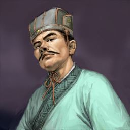
Chinese researchers discovered geographic areas outside of China. The traveler Zhang Qian (from the 2nd century B.C.) wrote about civilizations in the Middle East, India, and Central Asia. By the Tang dynasty (618-907), the Chinese diplomat Wang Xuance came into northeastern India in a place called Magadha. He wrote about India in his 7th century book Zhang Tian-zhu Guo Tu (the Illustrated Accounts of Central India). It had geographic information. Jia Dan (730-805) wrote about Iran and the Persian Gulf. Byzantine scholars wrote about geography like Stephanus of Byzantium (in the 6th century) called Ethnica. Famous Chinese explorer Zheng He was in the early Ming dynasty from the 1400's. He traveled into Brunei, Java, Thailand, Southeast Asia, India, the Horn of Africa, and Saudi Arabia. He sent back a giraffe, camels, ivory, zebras, etc. Muslims of Arabic and Persian descent were geographers too. Jābir ibn Hayyān (Geber or Jabir) (721– c. 815) wrote extensively on many subjects, expanded on the wisdom of the Greek classics and engaged in experimentation in natural science. It is unclear whether he was Persian or Syrian.

The map on the right shows the travels of the explorer Zheng He. He traveled as far west as Saudi Arabia and Africa.
In mathematical geography, Persian Abū Rayhān al-Bīrūnī, around 1025, was the first to describe a polar equi-azimuthal equidistant projection of the celestial sphere. He was also regarded as the most skilled when it came to mapping cities and measuring the distances between them, which he did for many cities in the Middle East and western Indian subcontinent. He combined astronomical readings and mathematical equations to record degrees of latitude and longitude and to measure the heights of mountains and depths of valleys, recorded in The Chronology of the Ancient Nations. He discussed human geography and the planetary habitability of the Earth, suggesting that roughly a quarter of the Earth's surface is habitable by humans. He solved a complex geodesic equation in order to accurately compute the Earth's circumference. His estimate of 6,339.9 km for the Earth radius was only 16.8 km less than the modern value of 6,356.7 km. By Medieval times, Marco Polo came into China. Many European explorers like Henry the Navigator of Portugal traveled into the African coast and studied geographic information. The Columbian exchange, the evil slave trade, and other events of colonialism continued to exist by the late Middle Ages to the early Modern Age. Geographic studies evolved from the time of the Scientific Revolution and the Reformation. The problem with some European geographic scholars back then was that many of them had Eurocentric biases that made them ignore non-European methods in studying geography. Alexander von Humboldt studied geography all of the time. The National Geographic Society was founded in the United States in 1888 and began publication of the National Geographic magazine which became and continues to be a great popularizer of geographic information. The society has long supported geographic research and education. By the 20th century, environmental determinism, regional geography, the quantitative revolution, and critical geography existed. Now, the study of geography has been grown by advanced technology, research, study, and other aspects of our human experiences.
By Timothy
No comments:
Post a Comment